A tropical cyclone could form near the Canary Islands in the next five days
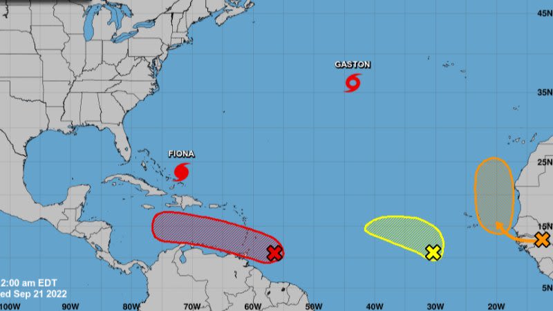
The National Hurricane Center in the United States and the State Meteorological Agency (Aemet) have announced that they are monitoring a tropical wave that is moving towards the west coast of Africa and that could lead to the formation of a tropical cyclone, although the possible impact on the Canary archipelago can't be estimated for certain at the moment.
Update - The cyclone is now classed as Tropical Storm Hermine, due to its rapidly increasing strength
According to Aemet, after a summer with very little cyclonic activity, the Atlantic seems to have "awakened" in September. There is quite a bit of activity right now, with a tropical storm, a hurricane, and three developing systems.
Of these three, only one of them has the potential to affect the Canaries in the next few days. The @NHC_Atlantic, based in Miami (USA), is in charge of monitoring and forecasting tropical cyclones in the Atlantic. They are currently monitoring a tropical wave that is forming in the interior of Africa and it will go out into the ocean in the vicinity of Cape Verde. When it breaks out into the Atlantic, it will probably move north and find favorable conditions for its intensification. Therefore, it is considered that there's a 50% chance of becoming a tropical cyclone within the next five days.
If the tropical cyclone ends up forming, the @NHC_Atlantic will inform in regards to its most likely "path cone"; at the moment there is a lot of uncertainty and it remains to be seen how it will affect the Canary Islands.
The probability that the most intense winds affect the archipelago is very low for now.
But it is likely that there will be intense wind gusts in the summits of the mountainous islands and, above all, that there will be rains in many parts of the archipelago starting on Saturday, weak to moderate that day, and that could increase in intensity on Sunday.
More info will be provided in the coming days as the system develops.


